
| Cave Formation | |||
| Training & Safety | |||
| Equipment | |||
| Projects | |||
| Papers | |||
| Photos | |||
| Video | |||
| Links | |||
| Contact Us | |||

 |
Azimuths are measured by using a waterproof compass with a fixed bezel mounted onto a slate. |
||
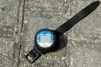 |
The easiest way to determine the depth in an underwater cave is by using a depth gauge. | ||
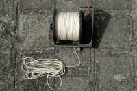 |
Distance is most often measured by counting knots, which have been placed every 10 feet on a line. A more accurate, but more time-consuming, way is by waterproof measuring tape. |
||
| When learning to survey underwater caves, it is best to start by practicing on land, then in the open water, and finally in a tourist cave. After each practice survey has ended, check for accuracy (most cartographers will be happy to assist you) before proceeding to the next practice area. Poor surveying methods make for a waste of time for everyone involved in an exploration project. | |||
| It does not matter whether one surveys going into or out of a cave PROVIDED that one stays aware of and adheres to the gas limits set for the dive. Especially when one surveys out of a cave, it is relatively easy to become distracted and temporarily forget that one has a limited supply of gas. Although getting the survey for a cave may seem important, it is certainly not worth endangering one’s life. One can always plan another dive to complete a survey; this can often be done in conjunction with checking leads. | |||
| Leads should be noted in terms of the stations to which they are close and their orientations (e.g., “S17 promising lead to NW”). Notes about what one observes (formations, coloration of the passage, water conditions, animals, etc.) should be made. Sketches of a passage are also very useful. |
|||
| Before one gives the information to the cartographer, one should review the notes to verify accuracy, legibility, and ease of understanding. Do not adjust the numbers, unless the cartographer has specifically asked you to do so. | |||
It is important that one obtains tie-in information for a line. Otherwise, the surveying exercise might be pointless—it may be impossible for the cartographer to pinpoint where the surveyed line can be found in the cave. Remember: one rarely has too much information on a line or passage, most often it is way too little. |
|||
